All Local, All The Time
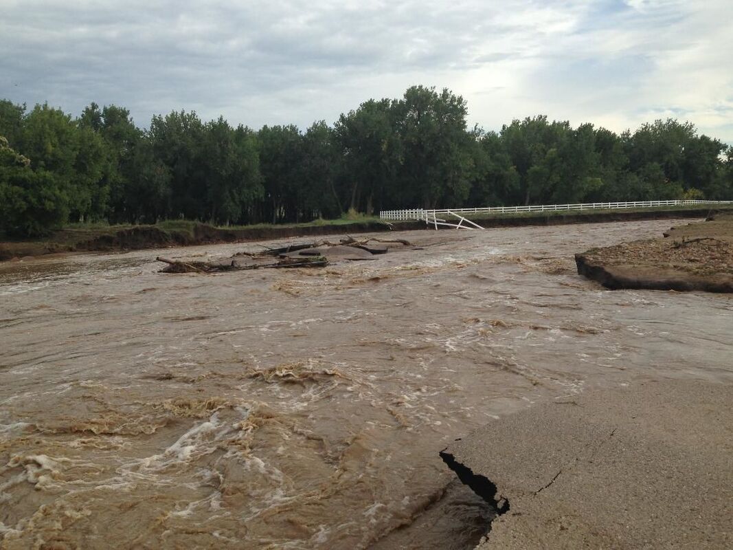
After the flood: What followed nature’s powerful punch in 2013

It was Sept. 12, 2013, when rain from a stalled storm began to swell and overrun the banks of nearly every waterway in Boulder County, assaulting massive amounts of personal property, streets, bridges, rocks and vegetation, disrupting lives for what would be years to come.

Left Hand Water District’s emergency response

“I have to say one of my least favorite things is revisiting the flood,” Left Hand Water District (LHWD) Manager Christopher Smith said. “I like the fact that it’s behind us.”

As water levels became unmanageable, LHWD posted this notice on its website: “Water Outage Notification: Overnight, several of the District’s main transmission lines were washed out by Boulder and Left Hand Creeks. Both of our water treatment plants are operational, but at this time we are unable to get raw water to the plants, and we are unable to convey treated water from the plants to some customers “

The three creeks that cross the district – Boulder, Left Hand, and St. Vrain – were all impaired. Fourteen sections of LHWD lines were breached, with pipes either broken or washed away completely. The consequence was a serious loss of pressure within the system and the emptying of four main storage tanks.

By the end of the day on Friday the 13th, water could no longer be treated, and based on protocol, boil alerts were sent out to customers.

Nimbus Road became a running river, making access to LHWD headquarters impossible. Employees who were able to head toward the facilities parked a quarter of a mile away and hiked in to discover that phone lines, gas, and electricity were all out of service.

Although the district had what Smith described as “robust emergency response scenarios in place,” contingency plans kept leading to dead ends.

“The 13th was the worst day,” Smith said. “Left Hand Water District has been around since 1962 and had never experienced anything like this.”

The water district had to patch together a crew of staff and engineering consultants to circuitously reach pipelines, assess the destruction, and reach shut-off valves to stop water from needlessly spilling out of broken pipes. Flooded roads and debris made for a huge challenge.

Nearly five days after the disaster, enough lines were plugged and rerouted that the majority of customers were back in the flow with clean water.

The cost of repairing the district’s infrastructure, both in the first few days and then permanently, came to $2.4 million. Federal Emergency Management Association (FEMA) and state disaster relief funds will cover $1.8 million, while the balance comes out of district reserves.

“We will be dealing with the state and feds on this reimbursement for at least another five years,” Smith said. This is within the normal timeframe for FEMA procedures, according to Smith. In the meantime, the district fronted the entire restoration cost.

By early 2014, the water district’s infrastructure repairs were completed, but environmental damages sustained to the 76 square-mile watershed that feeds LHWD resulted in years of rebuilding and to this day, those efforts continue.

Restoring Left Hand Watershed

Left Hand Watershed is the primary source of water for LHWD. The flow starts with snowmelt from Isabelle Glacier in Indian Peaks Wilderness and runs to Longmont where it meets with St. Vrain Creek.

Left Hand Watershed Oversight Group (LWOG) began in 2005 when the grassroots volunteer organization formed to address EPA-recognized health concerns around abandoned mine drainage within the corridor. Named Left Hand Watershed after the creek with the same name, its waterways supply irrigation and drinking water to 20,000 people in the water district.

Anglers, kayakers, hikers, and cyclists recreate throughout the watershed. The area is vibrant with natural beauty and is home to aquatic life, as well as birds and mammals, all relying on the water for their habitat and as a source of hydration. The land through which the watershed runs shifts between more than 100 privately owned parcels and portions owned by the U.S. government, Boulder County, and several municipalities.

Following the flood, LWOG’s axioms have revolved primarily around two goals: restoration and resiliency.

“The flood made for a more immediate concern and really changed the organization,” one of LWOG’s founders and the present treasurer of the group, Kathy Peterson, said. “Rather than just oversight, we actually became an active group that got funds through government grants to do restoration.”

Peterson was the manager of LHWD before retiring. LWOG’s legacy knowledge of the lay of the land and the course of the water were invaluable to formulating the master plan completed in late 2014. Boulder County led the charge in creating the master plan and worked in conjunction with more than 20 other stakeholders to address the devastation and prepare for the future.

Jessie Olson, executive director of LWOG, was hired in 2015 to tackle 20 projects identified within the master plan. The plan calls for moving giant amounts of debris, rebuilding bridges, rerouting creeks, making properly sized culverts, and shoring up banks. Of those projects, 11 are now complete, leaving nine more to go.

“While road reconstruction work was already completed in Left Hand Canyon,” Olson said “there are numerous privately owned sites still in need of stream restoration work to reduce risk to human life, natural systems, and infrastructure. “

Federal dollars funded 95 percent of the work, totaling approximately $10 million, according to Olson.

The work won’t end when the projects are complete, because water quality will need to be continually monitored and the dynamic environment of the waterways requires watching for shifting components within the infrastructure, Olson explained.

“It’s a testament to the community that so many people were involved,” Olson said of efforts in the last five years. “It involved our really amazing board of directors that facilitated this work and provided the leadership needed to implement this large number of projects in a short amount of time. The entities involved include the private landowners, the water district, the county, the City of Longmont, the Left Hand Ditch Company, the St. Vrain Water Conservancy District, the Jamestown Mayor and the City of Ward.”

Addressing the resiliency piece, Peterson said, “I do believe that the work we’ve done was carefully planned and that it will be less devastating, there would be less erosion in the creek, and there would be more experience in how to immediately recover from it.”

LWOG is a 501(c)3 organization and is looking for volunteers - what they call “citizen scientists” – to work in the field collecting data. They also rely on community members to fund the organization’s efforts in maintaining a healthy watershed and ensuring clean water at its source. Visit www.LWOG.org to learn more about how you can help.


Reader Comments(0)