All Local, All The Time
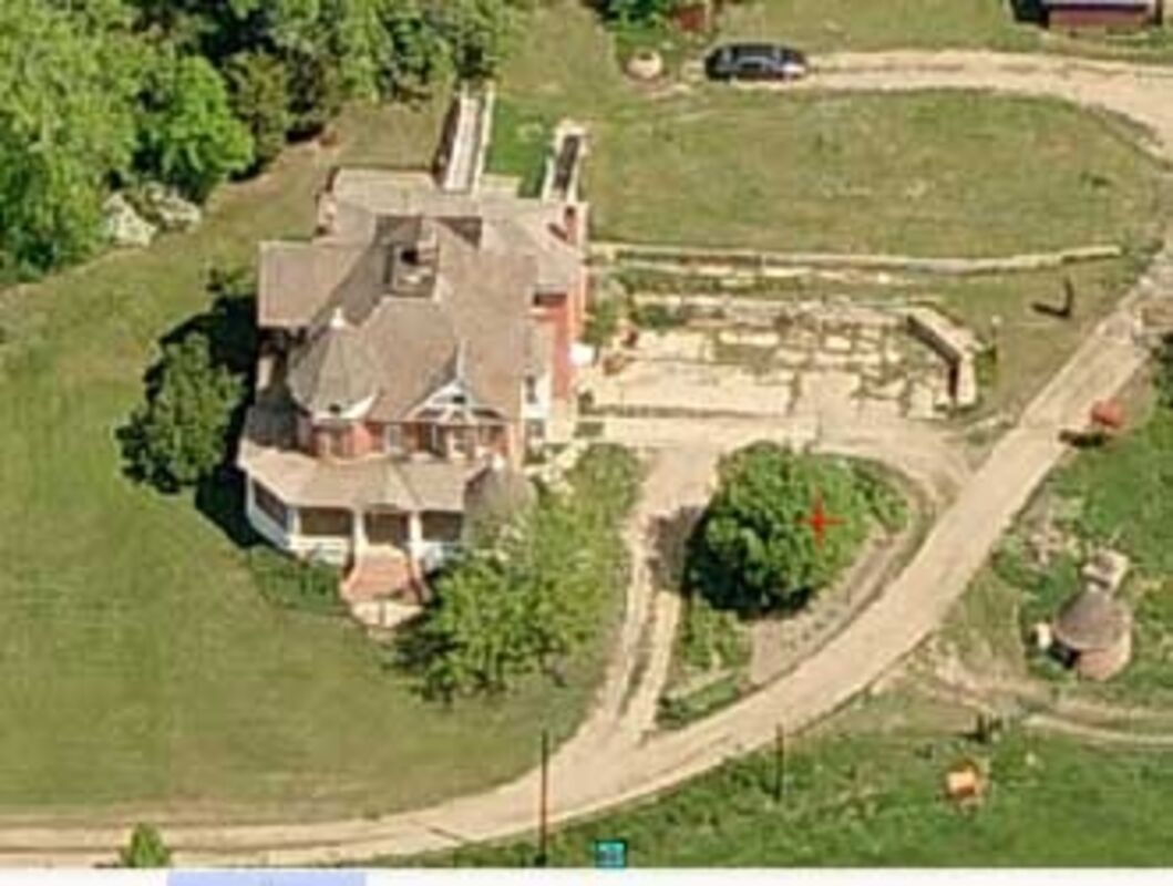
City of Boulder works with Tribal Representatives to develop plan for Fort Chambers site

The City of Boulder, through its Open Space and Mountain Parks Department, announced an effort to seek public input on a collaborative land stewardship plan to be developed for the site of the former Fort Chambers near Boulder Creek, just east of 63rd Street and south of Jay Road in the Gunbarrel area. The city purchased the property in 2018.

The city has recently worked with Arapaho and Cheyenne Tribal Representatives on a plan to use the land, now owned by the City of Boulder, to acknowledge the history, good and bad, of the open space land where Fort Chambers likely stood.

Fort Chambers is where Boulder-area men trained before participating in the Sand Creek Massacre on November 29, 1864, where Chief Niwot is believed to have been mortally wounded. It was also the site of the County Poor Farm used for care of indigent residents from 1902-1918, and the buildings used are still standing. The main house was listed on the National Register of Historic Places in 2011.

Phillip Yates, media specialist for the City's Mountain Parks and Open Space Department, said in a press release, "The City of Boulder extends its gratitude to Arapaho and Cheyenne Tribal Representatives for their guidance in developing a draft concept stewardship plan for open space land northeast of Boulder with a direct community connection to the Sand Creek Massacre.

"The city and Arapaho and Cheyenne Tribal Representatives welcome community feedback on a draft concept plan through an online questionnaire that will be open through Sunday, April 7. The city encourages community members to read the concept plan and share their input.

"The draft concept plan provides recommendations for how the city – with continuing guidance from Tribal Representatives – will care for land where Fort Chambers likely stood.... It will also help guide the city's ongoing work in acknowledging and communicating the role of Fort Chambers and the Boulder community in the Sand Creek Massacre."

According to the press release, from Aug. 28 to Sept. 16, 1864, more than 100 Boulder-area men of Company D of the Third Colorado Cavalry Regiment trained at Fort Chambers. The men of Company D later participated in the murder of 10 Cheyenne People on Oct. 9, 1864, as well as atrocities against peaceful Arapaho and Cheyenne People at the Sand Creek Massacre on Nov. 29, 1864.

Fred Mosqueda of the Southern Arapaho Tribal Community, who recently spoke to a standing-room-only crowd at the Left Hand Grange in Niwot as part of the Niwot Historical Society's Now & Then Lecture Series, said, "When we began work with city staff and visited the land, we shared all these stories and things that came from us. They listened to us with open minds so we could share our feelings of this place and for us all to understand where we were coming from and the things that happened on the land. As we began to understand what we could do together, I think it began to heal us by being able to talk about it and make this place a place to tell the whole story."

The community of Niwot, named for the Arapaho chief, was platted in 1975 by Porter T. Hinman and Ambrose Murray. Steve Hinman posted a comment on the Sand Creek Massacre Commemorative Commission website in 2014, saying, "Two of my ancestors rode with Chivington on that horrible day, Porter M. Hinman and his brother, Platte Hinman. They were under the command of Captain David Nichols as part of the Boulder volunteers. The irony of their participation was that their father, Porter T. Hinman, was a friend of Left Hand. My father could not forgive Porter M. and Platte for being a part of the slaughter .... Peace."

Lt. Joe Cramer of the Colorado First, who refused to fire, wrote: "Left Hand stood with his hands folded across his breast until he was shot, saying, 'Soldiers no hurt me - soldiers my friends."

A stone marker was erected at the Fort Chambers site in 1959, which said, "Site of Old Fort Chambers, 1/4 Mile East. Built on the farm of Geo. W. Chambers in 1864 and used during the Indian Uprising of 1864." The City of Boulder removed the marker in May 2023, due to its inaccurate description as an "Indian Uprising." But not everyone agrees that the stone should have been removed.

Mosqueda was reported as saying he still hopes the city will put the marker back up because it is part of Boulder's history. "The marker showed evidence that ... after all that time, 100 years (later), (people) still believed there was an uprising, and there was no uprising. So my first thought was, 'Let's straighten this out. Let's tell the true story of what was going on in Boulder.'"

Yates said, "City staff closely collaborated with Tribal Representatives from the Cheyenne and Arapaho Tribes, the Northern Arapaho Tribe and the Northern Cheyenne Tribe, to understand their Tribal Nations' desired long-term relationship with the land. Their guidance has led to a shared future vision for the land: 'Heal the Land; Heal the People.'"

Yates indicated that key elements of the concept plan include:

1. Ecological Restoration: Heal the land from past land uses and improve its ecological health through a large-scale restoration along Boulder Creek.

2. Healing Trail: Create Indigenous plantings, interpretive elements, and program areas to provide places for education, reflection, healing, and gathering.

3. Visitor Access: Develop an entrance drive that leads to a parking area with a bus drop-off to support visitors and provide site access.

4. Farmstead Improvements: Support ongoing agriculture, including diversified vegetable farming and irrigated hay fields. Recommendations also include restoration of the historic Queen Anne-style house and existing farm structure.

"We would like to make this a success story for everyone," said Chester Whiteman of the Southern Cheyenne tribal community, referring to planned, ongoing collaboration with Arapaho and Cheyenne Tribal Nations for the land where Fort Chambers likely stood. "This is going to take healing on all sides, all of the Nations that are involved in this – the Native and the Non-Native Nations. They all have to heal. It can't just be one-sided. Everybody has to work together to get to that point, and we need to come together to educate everybody that comes to this location."

The public is invited to provide feedback on the draft concept plan using an online questionnaire through Sunday, April 7.

The city will review public input and consider revisions with additional guidance from Tribal Representatives. Open Space and Mountain Parks staff anticipate presenting community feedback on the plan to the city's Open Space Board of Trustees this summer. After the concept plan is finalized, specific plan elements will be further developed with guidance from Tribal Representatives.

"Arapaho and Cheyenne Tribal Nations come in with a great knowledge of these lands here," said Ben Ridgley of the Northern Arapaho tribal community. "It's long overdue that we come out and give our sense of true history. That helps us to bring us to this point today, where we can collaborate together and build a better understanding of history, and work towards healing not only for the Tribes, but the State of Colorado and the people here."


Reader Comments(0)


Rendered 04/29/2024 20:26