
All Local, All The Time
All Local, All The Time
Aerial mulching operations began in the Cal-Wood Fire burn area at Heil Valley Ranch in early May.
Mulch is used to replace the organic ground cover that was destroyed by the wildfire and helps stabilize the soil in order to decrease erosion and reduce the risk of flooding.
Last year, the Cal-Wood Fire burned 10,113 acres and damaged or destroyed 26 structures. The fire, which was fully contained on Nov. 14, burned for nearly a month, and an investigation by the Boulder County Sheriff's office found the cause of the fire to be undetermined.
Now, six months later and after months of planning, modeling, surveying, and assessing fire damage, Boulder County Parks and Open Space, along with other key stakeholders, are beginning the recovery work on some of the land burned by the Cal-Wood Fire.
"We know this is basically a 10-year timeline in terms of the healing process of the landscape," said Sharla Benjamin, engineer and project manager with Boulder County Parks and Open Space.
The Cal-Wood fire, which started on Oct. 17, burned over 5,000 acres of Boulder County-owned property and conservation easements. A large part of the burned acreage was at Heil Valley Ranch, a 6,231-acre county-owned parcel with nearly 20 miles of multi-use trails. Certain areas of this public open space were part of the land that was most severely burned by the fast-moving Cal-wood fire, which initially torched nearly 5,000 acres in about five hours.
To help with the recovery process, Boulder County Parks and Open Space secured funding through the Natural Resources Conservation Service (NRCS), an agency of the United States Department of Agriculture (USDA). The NRCS Emergency Watershed Protection Program has provided $5.3 million to cover aerial mulching, sediment control, and improved early warning systems. Boulder County, as the local sponsor, will contribute 25% of this amount, or $1.2 million.
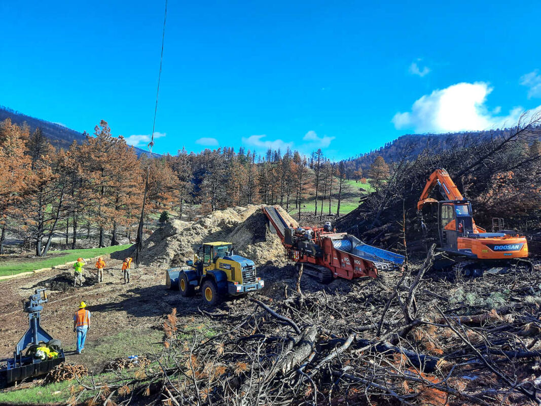
Aerial mulching operations began in early May with the goal of applying an average of five tons of wood shreds per acre for 70% coverage on the ground.
"We're looking at mulching over 1,600 acres on Heil and private property," said David Hirt, senior plant ecologist with Boulder County Parks and Open Space. "To date, we've done about 200 acres which is already over two million pounds of mulch."
The mulching process starts by cutting "hazard trees", which are any dead trees within 60 feet of the trails or the main access road and flying the trees to a landing site to be processed into mulch. The mulch is then dispersed back onto the hill slopes via helicopter.
"On a good day, they can do 150 to 220 trips a day," said Hirt. "It's a nice closed-loop system within the property where we're able to address the hazard trees that could be a public safety threat and then utilize them as mulch rather than bring in trees or agricultural straw from somewhere else."
Mulch is used to replace the organic ground cover that was destroyed by the wildfire and helps stabilize the soil in order to decrease erosion and reduce the risk of flooding. Hirt said it also helps lay down some organic matter and helps keep the soil moist which will help with the reseeding of future revegetation in the area.
"Even in the worst case with these fires, within a few years you see a regeneration of the vegetation naturally," said Hirt, although he said that future visitors should expect to see some changes in the landscape over time.
"The meadows will still be meadows, and they are extremely green right now and look great. The pine forests aren't going to come back for quite some time if they come back at all due to the extent of the burn, and there not being much seed source on site," said Hirt.
According to Hirt, research on wildfires in Colorado over the past few decades has shown that many of the burned forests are not regenerating due to changes in the climate, resulting in more shrubs and grasslands.
"A lot of those trails that used to snake through the ponderosa forest are going to be more open and grassland areas. There are still some pockets of live trees-not as many as we would have hoped for due to how extreme that fire was, but there's still some variety within the park," said Hirt.
Besides aerial mulching, the NRCS funding will cover sediment control and an improved early warning system for possible flash floods or debris flows. Engineer and project manager Sharla Benjamin is helping head up this work.
"When you have that severe of a burn, you have a soil structure that's basically destroyed and needs to be rebuilt naturally over time, but when it's being rebuilt it's vulnerable to rain and run-off," said Benjamin.
In addition to the loss of organic matter in the soil, Benjamin said the potential for soil erosion and flash flood events in the area is also heightened by the steep terrain and the presence of a hydrophobic layer in the soil.
This hydrophobic layer is formed when a waxy substance from the burned trees vaporizes and then condenses back into the soil, forming a water-repellent layer. Benjamin said this layer can effectively make the soil in an intensely burned area behave like a large paved parking lot when it rains.
"In urban areas, the rain will hit an asphalt or concrete parking lot and very rapidly run-off and create a lot of energy that takes out the soil downstream from the parking lot. And that's similar to what can happen in the burned areas," said Benjamin.
Additionally, Boulder County has been working in conjunction with the Boulder Office of Emergency Management (OEM) and the National Weather Service to implement an advance warning system to alert those downstream in the event of a flash flood or debris flow.
"We do a lot of modeling to try to predict how much rain, how much energy, how far that water will go in a given rain event," said Benjamin. "We'll find as many opportunities to capture and slow that water. We can't stop it, and floods will happen. We can only do our best to try to slow the water down and drop out the material," she said.
Based on predictive modeling and the forecast radar, the National Weather Service has currently set rainfall thresholds at which point it will issue an advanced warning via email and text alert. These alerts are designed to allow those in the floodplain to seek higher ground or, for other stakeholders like Left Hand Water, prepare for increased turbidity in the resulting run-off.
Meanwhile, Benjamin and her team will be working to build structures on site that will help slow down the flow of water. "We try to essentially create a terracing condition, slowing down the water and dropping out some of that sediment," said Benjamin.
These engineered structures, such as sediment basins, water breaks and check dams, should help direct and slow the run-off from future rain events.
"This is adaptive management. We don't know everything right now, and we're going to do our best to put structures in place. Then we'll watch and see how those rain events and streams interact with the structures and see whether we need to slightly modify, maintain, adapt, or move them," Benjamin said.
The NRCS funding end date is set as Sept. 9 and, currently, the south side of Heil Valley Ranch will be closed to the public at least through the end of September, at which point Boulder County will reassess the safety of opening the trails back up to the public. The northern trails accessible from Picture Rock Trailhead remain open for on-trail use.
"The next step for Heil Valley Ranch (after aerial mulching) will be our internal work to repair all the infrastructure within the park that needs repair," said Hirt. This includes three bridges that burned, trail work, signs and fencing that need to be rebuilt, and some reconstruction at the trailheads.
"That's going to be the next phase for us, addressing all those things so we can get the park back open to the public," said Hirt. He also noted there will likely be several volunteer opportunities for those interested in helping with the restoration efforts in the area.
For more information and current updates on the restoration project, visit: https://www.bouldercounty.org/open-space/management/heil-valley-ranch-cal-wood-fire-recovery/


Reader Comments(0)