
All Local, All The Time
All Local, All The Time
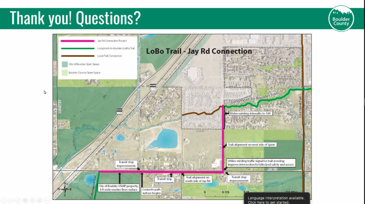
A virtual presentation by representatives of the City of Boulder and Boulder County describing the planned LoBo Trail connection on Jay Road and Spine Road was led by Tanya Luebbert of Boulder County.
On April 27, Boulder County's Community Planning and Permitting Department held a virtual meeting presentation for the Longmont-to-Boulder (LoBo) Trail Connection Project.
The LoBo Trail-Jay Road Connection is a planned off-street, multi-use path along Jay Road and Spine Road in Gunbarrel. The goal of the trail connection is to complete one of the final missing links in the LoBo Trail system, and create a safer, accessible, and more comfortable pathway between Gunbarrel and the Cottonwood Trail. The project will also improve five transit stops along the route and make safety improvements to the intersection of Jay Road and Spine Road.
Once complete, the only remaining gap in the LoBo Trail will be from Lookout Road to the Twin Lakes trailhead. At this time that section of the trail can only be traversed by on-street travel.
"We will be partnering with the City of Boulder, RTD, and Atkins (Engineering Consultant) for this project," said Boulder County Regional Trails Planner Tanya Luebbert. "This route will also provide the opportunity to provide five transit stops along Jay and Spine Road and implement pedestrian and bicycle safety."
The first section of the new trail connection will begin where the existing Cottonwood Trail coming from Boulder terminates at Jay Road between the Diagonal Highway and 55th Street. The Cottonwood Trail will turn directly east and will be located on the south side about 50 feet off of Jay Road.
The new route will avoid the trees and vegetation along Jay Road. Pedestrian push buttons will be added on the west side of Spine Road where it intersects with Jay Road. The trail will turn north at Spine Road and be located on the west side of Spine Road.
The Jay Road route was selected over a route along 55th Street due to "a lot more constraints along that route than we thought," Luebbert said. "That helped us determine that the grading and the right-of-ways would cause significant impacts to private property owners."
The estimated cost of the project is $1.7M, and not all of the funding is in place. Some of the funding will come from the transportation sales tax passed by voters in November 2022. Application for funding was made to DRCOG in January, but the project did not receive an award, and was instead placed on a waitlist.
"Currently, we are working on easements and agreements with adjacent property owners," Luebbert said. "We are working with ditch shareholders. The next steps will be the design process and we'll be working on maintenance agreements with the city. We plan to have final engineering design plans complete by the fall of 2023."
Questions from the public included a question as to whether the Jay Road portion of the trail would impact the prairie dog village along Jay Road. Luebbert responded, "We've aligned the trail in an area that as of now is avoiding prairie dog holes, and if we get to the stage of construction, and that's no longer the case, we will be following all of the City of Boulder's and OSMP's guidelines on their prairie dog practices."
One member of the public asked why there was not an underpass on Jay Road, and the county responded that adding an underpass would cost $5M to $6M to the $1.7M project. "We are doing everything we can to make that crossing at Jay Road and Spine safer for pedestrians and cyclists," Luebbert said.
For further information, contact Luebbert at [email protected].


Reader Comments(0)